
The media has begun paying more attention to Syria as the country’s 54-year old regime has fallen to insurgents tied to ISIS and Turkey. As part of its coverage, it has marked the Golan Heights on its maps. It makes this an opportune time to review the very different coverage of two contested areas – Golan Heights and West Bank – between Israel and its neighbors.
In the Media
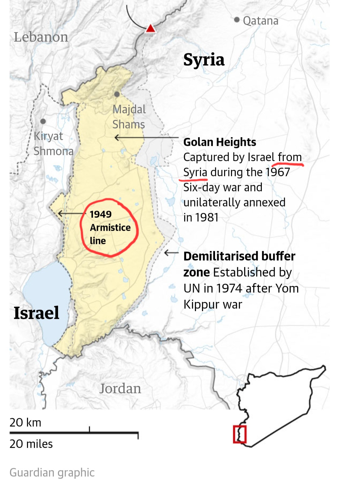
The Guardian presented a map of the Golan Heights calling the separation between Israel and Syria as the “1949 Armistice line.” It also noted that the Heights were “captured by Israel from Syria during the 1967 Six-day war.” Both of these statements are factually correct.
And completely divorced from how the media describes the “West Bank.”
Rather than use the term “1949 Armistice line”, the press calls it the “1967 border” even though it was never a border nor meant to be a border. As described in the 1949 Israel-Jordan Armistice Agreement in Article VI, “The Armistice Demarcation Lines defined in articles V and VI of this Agreement are agreed upon by the Parties without prejudice to future territorial settlements or boundary lines or to claims of either Party relating thereto.” In other words, the lines were simply set to separate the warring parties but political negotiations would craft the contours of the land in the future.
In regards to the phrase “from Syria,” the media never notes that Israel didn’t capture the “West Bank” land from Palestine but from Jordan, as Palestine did not exist.
The media – and the United Nations – mislead people that Israel took the West Bank from Palestine in an aggressive war. That is completely untrue, and obfuscated by terminology.
Geography
The Golan Heights are an actual topographical piece of earth. The large hills and mountains shoot up from the Sea of Galilee and beyond from volcanic activity.
Not so for the “West Bank.” It has no geographical or historical significance, other than being east of the 1949 Armistice line. It wasn’t even called the “West Bank” until after the 1967 Six-day war, as Jordan had illegally annexed it in 1950 and the UN just called it part of Jordan.
Arab States Breaking the Armistice Agreements
The Israel-Syria and Israel-Jordan Armistice Agreements specifically called on all parties to not take military action against the other. Both Arab states violated those agreements.
Syria shelled the farmlands of Israel’s Galilee for years, forcing Israel to defend itself and take the Golan Heights to keep Syria from repeating the attacks. Similarly, Jordan attacked Israel in June 1967 and Israel captured the region in a defensive action during the Six-day war.
Internationally Defined Borders
International powers created the various lines for Lebanon, Syria, Iraq and Palestine after World War I. Each region slowly declared independence but not without difficulties. Each has gone through several wars, including civil wars. A populace more comfortable with tribes and clans operating under the umbrella of the Ottoman Empire for centuries were thrust into statehood. While modern academics blame the regional powers for “colonialization” and “imperialism” which left the locals bereft of natural resources, it was actually the imposition of statehood that has confounded much of the Middle East. Syria, Iraq and Lebanon are perfect examples of the internal strife which has killed millions over the decades.
“Palestine” was similarly crafted by world powers, and then quickly divided further by chopping off the region east of the Jordan River for the Hashemite Kingdom to rule. The balance of the land (which most people think of as pre-1948 Palestine) was designed to be “a national home for the Jewish people,” in the Palestine Mandate as adopted by the League of Nations. While the Golan Heights was marked by the powers to be part of Syria, those same powers marked the “West Bank” to be part of the Jewish homeland.
On one hand, Israel captured the Golan Heights after Syria broke the Armistice Agreement, and on the other, Israel RECAPTURED the West Bank/ area east of the 1949 Armistice Lines, in 1967 after Jordan broke its Armistice Agreement.
Names
Republicans in the United States are putting forward resolutions to stop calling the land “West Bank” and instead refer to it as “Judea and Samaria.” Sen. Tom Cotton (R-AK) said in introducing the resolution that “The Jewish people’s legal and historic rights to Judea and Samaria goes back thousands of years. The U.S. should stop using the politically charged term West Bank to refer to the biblical heartland of Israel.” That is partially true.
Judea and Samaria have historical context and are much bigger contours than the “West Bank.” The West Bank is an artifice of war; it is just the land the the Jordanians took in the 1948-9 war in which they attempted to destroy the nascent Jewish State. The more accurate term for political purposes would be to call it E49JAL, for the area east of the 1949 Jordanian Armistice Lines.
Conclusion
The media is correctly referring to the Golan Heights, an actual region with topographical significance, as having an Israeli side captured FROM SYRIA, across the “1949 Armistice line.” It should similarly stop using the terms “borders,” “West Bank” and “from Palestine” which are all factually incorrect and attempt to frame the conflict with the Stateless Arabs from Palestine (SAPs) in a duplicitous manner that portrays Israel as the aggressor.

